MIZORAM
The name, Mizoram derived from Mi (people), Zo(high rise place such as hill) and Ram(land), thus, Mizoram means “Land of the hill people”. As situated in the northeast, it is the southernmost landlocked state sharing borders with three of the seven states namely Tripura, Assam and Manipur. Mizoram also shares 404 kilometre border with Myanmar and 318 km with Bangladesh.
The Mizo Hills were formally declared as a part of British India in 1989, north and south hills were united into a Lushai Hill Districts and it was under the administrative control of the British India. On 25th April 1952, The Lushai Hills Autonomous District Council came into being followed by the abolition of chieftainship in the Mizo society. Like several other northeastern states of India, Mizoram was a part of Assam until 1972, when it was declared as a Union Territory. On 20th February 1987, it became the 23rd state of India, with Fifty-Third Amendment of Indian Constitution,1986.
Mizoram is the fifth smallest state of India with 21,087 km2 (8,142 sq mi). It extends from 21°56'N to 24°31'N, and 92°16'E to 93°26'E.The tropic of cancer runs through the state nearly at its middle. Situated on a mountainous area with heavy rainfall of approximately 2500mm annually, Mizoram is richly endowed by nature with varieties of flora and fauna.
Mizoram is anointing with a pleasant climate; moderately hot during summer and extreme cold is unusual during winter. The south-west monsoon reaches the state around May and may last upto September.
2. FOREST DEPARTMENT
A stretch of forests adjacent to Cachar District of Assam was constituted as Innerline Reserved Forest under Assam Forest Department in 1930 and it was administered by Deputy Commissioner till 21.1.1972. However, forests in other parts of Mizoram were administered by Mizoram Autonomous District Council since 1952 headed by Additional Deputy Commissioner as DFO and one ACF and other staff with a creation of Forest Department.
When Mizoram attained Union Territory, the Forest Department became full fledged Department headed by Director of the rank of Conservator of Forests. This post was upgraded to the post of Chief Conservator of Forests on 29.12.1983. Northern Circle and Southern Circle were created on 13.1.1984. Another Circle, Research & Development was created on 5.8.1987. The Department was renamed as Environment and Forest Department with the creation of one Principal Chief Conservator of Forest on 10.12.1987.
The organization in the Department has been further upgraded and at present there are 4 territorial circles, Northern Circle, Southern Circle,Central Circle and Eastern Circle with 13 territorial divisions, 1 functional circle with 5 functional divisions and 1 Chief Wildlife Warden with 3 wildlife divisions and 1 Tiger Reserve.
Circles and divisions (Territorial and wildlife)
Name of Circles | Divisions |
|
|
|
|
|
|
Eastern Circle |
|
|
|
|
|
3. MIZORAM FOREST AT A GLANCE
According to India State of Forest report, 2015, an area of 18,748 Sq km which is 88.93% of the total geographical area of the state, i.e. 21,081 sq km is under Forest Area. According to the report, Mizoram has an area of 138 sq km Very Dense Forest (VDF), 5,858 sq km of Moderately Dense Forest (MDF) and an area of 12,752 sq km of Open Forest (OF). District-wise Forest Cover of Mizoram is mention in the table below:
Table: District-wise Forest Cover of Mizoram (Area in sq km)
District | Geographical area (GA) | Very Dense Forest | Moderately Dense Forest | Open Forest | Total | Percent of GA |
Aizawl | 3,575 | 28 | 1,135 | 2,022 | 3,185 | 89.09 |
Champhai | 3,185 | 60 | 1,042 | 1,570 | 2,673 | 83.92 |
Kolasib | 1,382 | 0 | 187 | 1,027 | 1,214 | 87.84 |
Lawngtlai | 2,557 | 0 | 705 | 1,632 | 2,337 | 91.40 |
Lunglei | 4,536 | 1 | 1,186 | 2,954 | 4,141 | 91.29 |
Mamit | 3,025 | 43 | 654 | 2,044 | 2,741 | 90.61 |
Saiha | 1,400 | 0 | 551 | 696 | 1,247 | 85.22 |
Serchhip | 1,421 | 6 | 398 | 807 | 1,211 | 85.22 |
Total | 21,081 | 138 | 5,858 | 12,752 | 18,748 | 88.93 |
Source: ISFR,2015
Table: District-wise forests cover in percentage
District | Aizawl | Champhai | Kolasib | Lawngtlai | Lunglei | Mamit | Saiha | Serchhip |
Very Dense Forest | 0.78% | 1.9% | - | - | 0.022% | 1.40% | - | 0.40% |
Moderately Dense Forest | 31.74% | 32.70% | 13.5% | 27.6% | 26.10% | 21.60% | 39.40% | 28.00% |
Open Forest | 56.55% | 49.30% | 74.30% | 63.8% | 65.10% | 90.60% | 49.70% | 56.80% |
Source: ISFR,2015
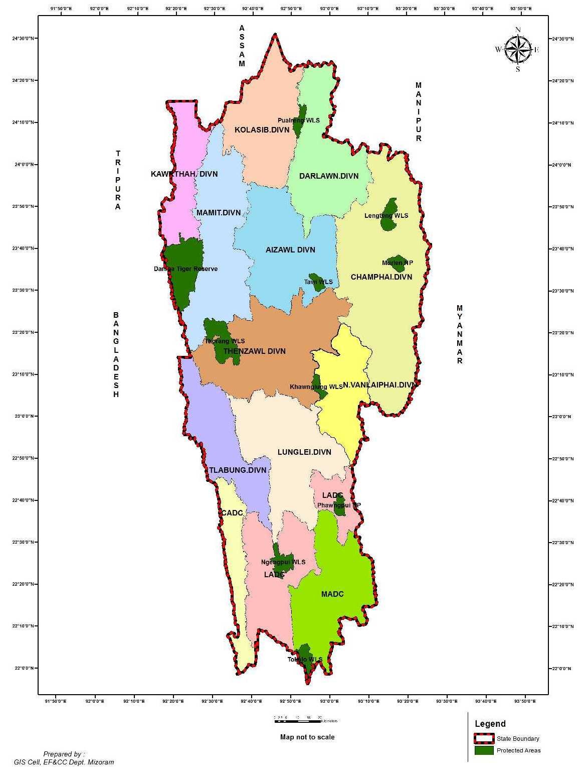
4. Map of Mizoram showing Divisions and Protected Areas of EF&CC Dept.


