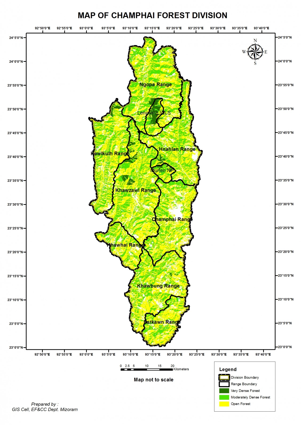
1. Name of Division : Champhai Forest Division
2. Brief Note :
A. Area: 3128.398 SqKm
B. Location: It lies between23°-24°OS 'North latitude & 93°to93°26'East of longitude.
C. History of the Division - Champhai District is one of the eight districts of Mizoram state in India.The district is bounded on the north by Churachandpur district of Manipur state, on the west by Aizawl and Serchhip districts, and on the south and east by Myanmar. The district occupies an area of 3128.398km2 Champhai Forest Division occupies almost all the areas of the district representing the eastern most boundary of India with Myanmar. Inspite of its highest elevation among eight districts of the sate it is famous for having he largest plain areas of the state which are used for wet rice cultivation which make it to name Ricebowl of the state. This frontier Division has special place in history of Mizoram and its people.

Places of interest : Champhai Forest Division consists of many historical sites which form tourists attractions, some of which are:-
Rih Dil: Rih Dil occupied an important status in the traditional religion of the Mizo people. According to the ancestors of the tribals, it was a corridor to their heaven called Pialral. All souls destined to Pialral must pass through the lake. Due to its cultural importance it is often said 'the largest lake in Mizoram is Rih Dil, but is in Burma. It is a natural lake located at north western Chin state at 3 km from Zokhawthar village at an lndo-Myanmar border. It is 1 mile in length and half mile in width.
Hringlangtlang: It is a hill ock located at the north west of Rih Dil, it is a mythical mountain on the way to Mitthikhua-an eternal abode of man 'Supply Reserved soul, from which the newly departed soul look back and view with longing the world of man from which they have departed.
Tan tlang: The Tan mountain with a height of 6,027 feet (1,837m) is the fifthtallest mountainin Mizoram. TheTan mountain is the living placed for Lasi, popularly known as Chawngtinlerhi like a wizard, Lasi can do anything they wish for.
Mizo Hlakungpui Mual (Mizo Poets' Square): It is a monument to commemorate Mizo poets. It was set up in 1986 at the southern edge of Khawbung Village. It is one o Flora - tourist attractions of Chamhpai District.
Lungkhawdur-Vanchengpui, Literally 'Cloudy Stone', Lungkhawdur is located near Vanchengpui village. This is a large flat stone with a mass of elliptical shapes embossed on its surface resembling the alto cumulus formation of clouds. It is difficult to as certain whether it is natural or man-made. On the upper and lower ends are deep grooves following the same pattern, similar to the preliminary lines a sculptor would have made for a large work.
Kawtchhuah Ropui: The 171 menhir stones in Vangchhia village became Mizoram’s first protected archaeological site in 2012.
D.
Rihdil
3. Name of Ranges:
S.No | Name of Range | Geogriphical Area (in sq.km) |
1 | Champhai | 402.00 |
2 | Khawzawl | 578.474 |
3 | Kawlkulh | 402.602 |
4 | Ngopa | 537.087 |
5 | Khawhai | 166.556 |
6 | Khawbung | 448.211 |
7 | Farkawn | 194.812 |
8 | Hnahlan | 398.656 |
4. Reserved Forest:
Name of Reserved Forest | Name of Range Range | Area(in\Sq.km) | Notification No. |
Ngur RF | Champhai | 10.80 | No.EL.12/65 of 10.10.1965 |
Ngur Zo RF | Champhai | 2.15 | The Mizoram Gazette extra Ordinary published by Authority 19.12.1997 |
Tuivawl RRF | Kawlkulh | 33.30 | ADC Supplt.to the Assam Gazette May 19.1965 |
TuivaiRRF | Ngopa | 49.80 | ADC Supplt. to the Assam Gazette May 19.1965 |
Tuisen RF | Khawzawl | 10.80 | No.EL.12/65 of 10.10.1965 |
Lianpui RF | Khawbung | 8 | No.EL.12/65 of 10.10.1965 |
Hnahlan RF | Hnahlan | 2.50 | No.EL.12/65 of 10.10.1965 |
Tuikual RF | Hnahlan | 8 | No.EL.12/65 of 10.10.1965 |
Ngaizawl(Tlangcheng} RF | Khawzawl | 2.46 | The Mizoram Gazette extraordinary published by Authority 19.12.1997 |
Vankal(Lawnpui}RF | Khawzawl | 2.90 | The Mizoram Gazette extra Ordinary published by Authority 19.12.1997 |
Khawhriam(Arro}RF | Khawzawl | 2.95 | The Mizoram Gazette extraordinary published by Authority19.12.1997 |
DarkhuangbawkRF | Kawlkulh | 4.11 | The Mizoram Gazette extra ordinary published by Authority 19.12.1997 |
PhuihnamramRF | Khawbung | 2.88 | The Mizoram Gazette extraordinary published by Authority19.12.1997 |
BuhnekkawnRF | Ngopa | 2.77 | No.L.11011/1/95-REV.Dt.27.3.2001 |
Darsam RF | Khawhai | 2.08 | The Mizoram Gazette extraordinary published by Authority 19.12.1997 |
5. National Park/Sanctuary, if any:
Murlen National Park: Murlen National Park is located in Champhai Forest Division. The size of the park area is 100 Sqkm. The park is situated about 245 km east of Aizawl, and is close to the Chin Hills. It lies south of Lengteng Wildlife Sanctuary in the same district. It covers an area of approximately 1OO sqkm. The tropical, semi-evergreen and sub montane Forests of Murlen are home to a rich variety of flora and fauna. About 15 species of mammals, 150 species of birds, 35 species of Medicinal plants, 2 species of bamboos, and 4 species of orchids so far have been recorded in this Park. Murlen National Park was declared in 1991.
Only about 1% of the suns' Supply Reserved ray can penetrate the forest on a sunny day. So the thickness of the forest in the park is generally compared to the forest found in the Amazon region in South America. Some of the trees found in the park area sold as 350 years.
Lengteng Wildlife Sanctuary: Lengteng Wildlife Sanctuary is located in Champhai district,only a few kilometers from lndo Myanmar Border and north of Murlen National Park. It lies adjacent to the village Lamzawl, and the nearest town is Ngopa, Selam village is within the sanctuary. It is at an altitude of 400- 2,141msl. It covers an area of 60 sqkm. It consists of several mountain peaks, and one of them is the second highest in Mizoram. Vegetation types are tropical evergreen forest and sub-tropical montane forest. Lengteng is densely covered with evergreen and semi-evergreen trees. The administration is under the state government through the Department of Environment Forests & Climate Change.
Flora: Flora found under Champhai Forest Division are Quercus
leucotrichophora, Lithocarpus, dealbata, Schima wallichii, Lyonia ovalifolia and Vaccinium sprengelii. Quercus, Schimawallichii, Betula, Michelia champaca, Pinuskesiya, Prunus, Myrica, Rhododendron, Chimonobambusa callosa, cane sand a variety of orchids and lichens etc. Common herbs are Ageratum adenophorum, Maesa indica and Euryacerasifolia etc.
6. Fauna :Fauna found under Champhai Forest Division are-tiger, leopard, sambar deer,barkingdeer,goral, serow,hoolockgibbon, rhesusmacaque and wild boars, northern pig-tailed macaque,Malayan giant squirrel, Himalayan black bear, serow. Hume' Pheasant pheasant, kalij pheasant ,grey partridge, hill myna, dark-rumped swift, grey sibia, grey peacock pheasant, Oriental pied hornbill, rufous-bellied eagle, and white-naped
yuhina. Blyth's tragopan etc.
7. Incumbency of DFO:
SI.No
Name
Designation
Tenure
- 1
- C.Ramhluna
- IFS
- 21.11.84-12.8.85
- 2
- LiankimaLailung
- MFS
- 13.8.85-2.11.86
- 3
- B.Suanzalanga
- MFS
- 3.11.86-23.5.88
- 4
- Hmingdailova Colney
- MFS
- 24.5.88-15.6.88
- 5
- LiankimaLailung
- MFS
- 16.6.88-13.11.89
- 6
- LalthanglianaMurray
- MFS
- 14.11.89-21.6.94
- 7
- Vanlalsawma
- IFS
- 22.6.94-6.7.99
- 8
- LiankimaLailung
- IFS
- 7.7.99-26.7.05
- 9
- Vanlalsiama Khawlhring
- IFS
- 27.7.05-21.12.09
- 10
- C.Vanlalena
- MFS
- 21.12.09-14.12.12
- 11
- Vanlalchuailova
- MFS/IFS
- 14.12.12-30.3.17
- 12
- Lalchhuanmawia
- MFS
- 30.3.2017-21.9.17
- 13
- C.Lalbiaka
- IFS
- 21.9.17-


